Bolivia Trek Expedition Itinerary
Day 1
Depart country of origin.
Day 2
Arrive La Paz, Bolivia. We’ll travel from the dizzying heights of the El Alto Airport (13,323 ft / 4061 m) on the altiplano (high altitude plateau) and drop into the city of La Paz. La Paz, with an average elevation of 11,975 ft / 3650 m, is the highest capitol city in the world. The city was founded in a bowl like depression beside the altiplano and has grown expanding upward in spectacular form with buildings clinging to the rugged canyon walls. We’ll spend the day acclimatizing and taking in views of the Cordillera Real (Royal Range) by riding the longest and highest urban cable car network in the world and with a city tour. We’ll also have a thorough equipment check and orientation at the hotel.
Overnight at hotel in La Paz (11,810 ft / 3600 m)
Day 3
Today we leave the city and drive along the shores of Lake Titicaca, the world’s largest high altitude lake and the mythical birthplace of the Incas. Our destination is the small lakeside village of Santiago de Huata, where we will enjoy lunch organized by the village community tourism project, followed by a small tour of the lake on a catamaran, a visit to the village, and an acclimatization walk along the lakeshore.
Overnight in basic hostel in Santiago de Huata (12,600 ft / 3840 m)
Day 4
From Santiago to Huata, we will enjoy views of the shores of the lake and the enormous Ancohuma massif (21,086 ft / 6427 m) as we drive to the village of Santiago de Okola. Here we will spend part of the day trekking above and beside the lake alongside rural communities and participate in another local community tourism project dedicated to sharing both the beauty of the region and the local way of life.
Overnight in basic hostel in Santiago de Okola (12,600 ft / 3840 m)
Day 5
In the morning, we will hike to the top of the Dragon Dormido or the Sleeping Dragon, the aptly named rock formation for which the local community is known. The summit, at 13,435 ft / 4095 m, affords absolutely spectacular views of the Cordillera Real mountain range, Lake Titicaca, and the surrounding rural farmland. In the afternoon, we will drive to a scenic camping area above the village of Sorata, with views over the layers of hillsides below the peaks of Illampu and Ancohuma.
Overnight in tents near Sorata pass (13,600 ft / 4150 m)
Day 6
Today we begin the true trekking portion of our trip with a hike along the crest directly opposite the enormous Ancohuma massif. With good weather, we will enjoy expansive views of the glaciated peaks of the north end of the Royal Range and the rural agricultural villages on the lower slopes. We’ll traverse above and eventually pass through the highest villages to reach our campsite on the southwest slopes below Pyramid Peak.
Overnight in tents above Alto Lojena (13,290 ft / 4050 m)
Trekking Time with Breaks: 6 hrs
Distance: 5.6 miles / 9 km
High Point: 13,290 ft / 4050 m
Total Elevation Gain and Loss: + 2,130 / – 1,740 ft (+ 650 m / – 530 m)
Day 7
From Alto Lojena, we will curve around the south easterly slopes of the Ancohuma massif and the most heavily glaciated part of the Royal Range before dropping into the deep valley above San Francisco Lagoon. For a relaxing finish to our day, we can take a dip in the natural hot springs located a short distance from our campsite.
Overnight in tents above San Francisco Lagoon (14,860 ft / 4530 m)
Trekking Time with Breaks: 6 hrs
Distance: 6.8 miles / 11 km
High Point: 16,100 ft / 4900 m
Total Elevation Gain and Loss: + 2,600 ft / – 1,200 ft (+ 800 m / – 360 m)
Day 8
We will begin the day with a climb out of the valley above San Francisco Lake and then curve our way east over several ridges on sandy slopes with views of Kasiri Peak. Our destination for the day is Chojña Khota, or Green Lake in the indigenous Aymara language, and the slopes below Paso Calzada. Paso Calzada is the only non-technical pass affording access to the north side of the Royal Range in a 30 mile long stretch of glaciers and jagged peaks.
Overnight in tents at Chojña Khota Lake (15,650 ft / 4770 m)
Trekking Time with Breaks: 6 hrs
Distance: 6.2 miles / 10 km
High Point: 16,400 ft / 5000 m
Total Elevation Gain and Loss: + 1,500 ft / – 750 ft (+ 460 m / – 230 m)
Day 9
A morning ascent from Chojña Khota brings us to a pass that marks our high point of the day. From the pass, we begin our descent into the next valley, containing a series of lakes and a river that form the glacial outlets of Chearoco and Calzada peaks.
Overnight in tents at Jistaña Khota Lagoon (15,100 ft / 4600 m)
Trekking Time with Breaks: 5 hrs
Distance: 3.5 miles / 5.6 km
High Point: 16,700 ft / 5100 m
Total Elevation Gain and Loss: + 1,100 / – 1650 ft (+ 330 m / – 500 m)
Day 10
Our trek today begins with an ascent above Jistaña Khota Lagoon, affording views of Kasiri and Calzada peaks, two difficult to access and rarely climbed summits. We will continue traversing around several ridges before descending into the picturesque Kelluani Valley, which extends below the western slopes of 6000 meter plus Chearoco.
Overnight in tents in Kelluani Valley (15,200 ft / 4635 m)
Trekking Time with Breaks: 6 hrs
Distance: 4.7 miles / 7.5 km
High Point: 16,600 ft / 5060 m
Total Elevation Gain and Loss: + 2,360 / – 2,130 ft (+ 720 m / – 650 m)
Day 11
Today we will trek over a pass in the ridges that separate the valleys below the peaks of Chearoco and Chachacomani, two 6000 meter plus peaks. We will have impressive views of both of those peaks and the farther reaches of the Cordillera Real. Conditions permitting, we will also make an ascent of the trekking peak Chachatuju and reach our highest point of the trip.
Overnight in tents at base camp of Chachacomani (14,630 ft / 4460 m)
Trekking Time with Breaks: 8 – 9 hrs
Distance: 5.6 miles / 9 km
High Point: 17,585 ft / 5360 m
Total Elevation Gain and Loss: + 2,400 / – 2,950 ft (+ 725 m / – 900 m)
Day 12
We will continue up the valley towards the mountains and over a pass with expansive views of Chachacomani. From the pass, we descend into the Jayllihuaya valley and curve around to a platform that forms the entrance to a higher valley below the peak of Warawarani.
Overnight in tents at Jayllihuaya Valley (15,160 ft / 4620 m)
Trekking Time with Breaks: 8 hrs
Distance: 6.8 miles / 11 km
High Point: 16,540 ft / 5040 m
Total Elevation Gain and Loss: + 2,560 / – 2,030 ft (+ 780 m / – 620 m)
Day 13
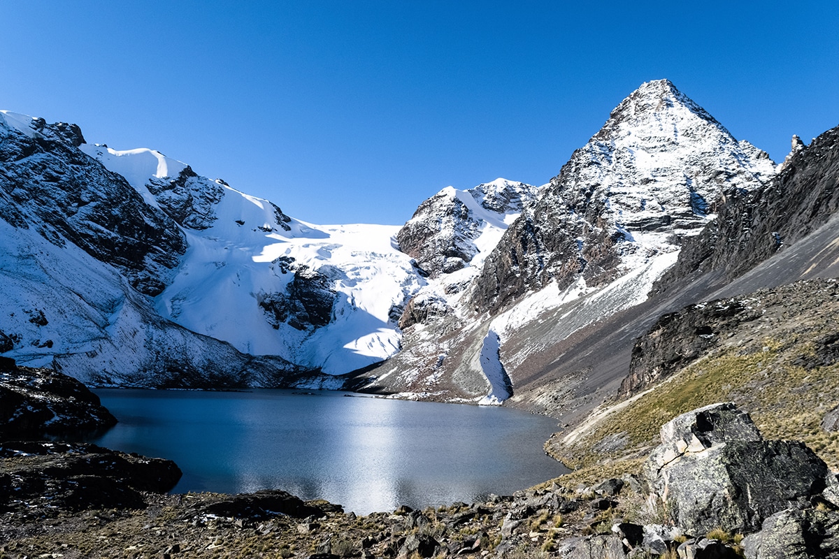
Our final day of trekking takes us to the hidden lake below the cirque of smaller peaks dominated by the enchanting black pyramidal Warawarani (18,182 ft / 5542 m), which means “the place of the stars” in the indigenous Aymara language. We climb from the lake to a pass and down into the next valley before climbing a final pass and descending to the large blue Thiya Khotia Lake. Our driver will meet us at Thiya Khotia Lake for the return trip to La Paz.
Overnight at hotel in La Paz (11,810 ft / 3600 m)
Trekking Time with Breaks: 6.5 – 7 hrs
Distance: 7.1 miles / 11.5 km
High Point: 16,535 ft / 5040 m
Total Elevation Gain and Loss: + 2,160 / – 2,950 ft (+ 660 m / – 900 m)
Day 14
Depart La Paz.
Please note that trekking times, distances, and elevation gains are approximate. We will be trekking through a remote and wild mountain region and, while we have established destination points, we will often not be following any kind of established trekking route or visible trail. Be prepared to walk on varying types of terrain, including scree. Not being on a well established trekking route is one of the wonderful aspects of this trip, but it can make our progress more arduous.
This is a note to let you know what my experience was in Zermatt and with Johnathon and Hans. I would like to say that I have done climbing numerous peaks over the last 25 years. I have used guides a number of times and have never experienced the quality of the guides Johnathon, Hans, […]